Back Århus Å CEB Aarhus Å Danish Aarhus Å German Río Aarhus Spanish Aarhus (rivière) French Aarhus (fiume) Italian Орхус (река) Russian Århus Å Swedish
| Aarhus River | |
|---|---|
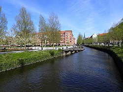
 Århus Å flowing through the city centre of Aarhus. Here at Mølleparken close to its mouth on Aarhus Harbour. | |
| Native name | Århus Å (Danish) |
| Location | |
| Country | Denmark |
| Region | Jutland |
| District | Central Denmark Region |
| Municipality | Skanderborg Municipality, Aarhus Municipality |
| Physical characteristics | |
| Source | Astrup Mose |
| • location | Skanderborg Municipality |
| • coordinates | 56°1′47.8″N 10°5′37.9″E / 56.029944°N 10.093861°E |
| • elevation | 54 m (177 ft) |
| Mouth | Port of Aarhus |
• location | Aarhus Bay |
• coordinates | 56°9′9.6″N 10°12′48.5″E / 56.152667°N 10.213472°E |
• elevation | 0 m (0 ft) |
| Length | 40 km (25 mi) |
| Basin size | 324 km2 (125 sq mi) |
Aarhus River (Danish: Århus Å) is a 40-kilometre (25 mi) long river, in eastern Jutland, Denmark.
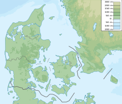
The river flows through the large river valley of Aarhus Ådal. The valley itself, stretches from Silkeborg to the coastal city of Aarhus, but the Aarhus River only runs through the easternmost parts.[1] The river drains a basin of 324 square kilometres (125 sq mi) in the eastern part of Søhøjlandet and discharges into the Bay of Aarhus which is an embayment of the Kattegat. It originates 54 metres (177 ft) above sea level in the swampy bogland of Astrup Mose close to Stilling-Solbjerg Lake, southwest of the city of Aarhus (56°6' northern latitude, 10°9' eastern longitude) and exits into Aarhus Harbour at 56°9' northern latitude, 10°13' eastern longitude. The river defines the border between Skanderborg and Aarhus Municipality during its first few kilometres.
- ^ Marianne Krog Skajem. "Undervisningsforløb om Aarhus Ådal med særligt fokus på Brabrand Sø og Årslev Engsø" (PDF) (in Danish). NTS Centeret. Archived from the original (PDF) on 4 March 2016. Retrieved 25 November 2014. Educational material about Aarhus Ådal.

